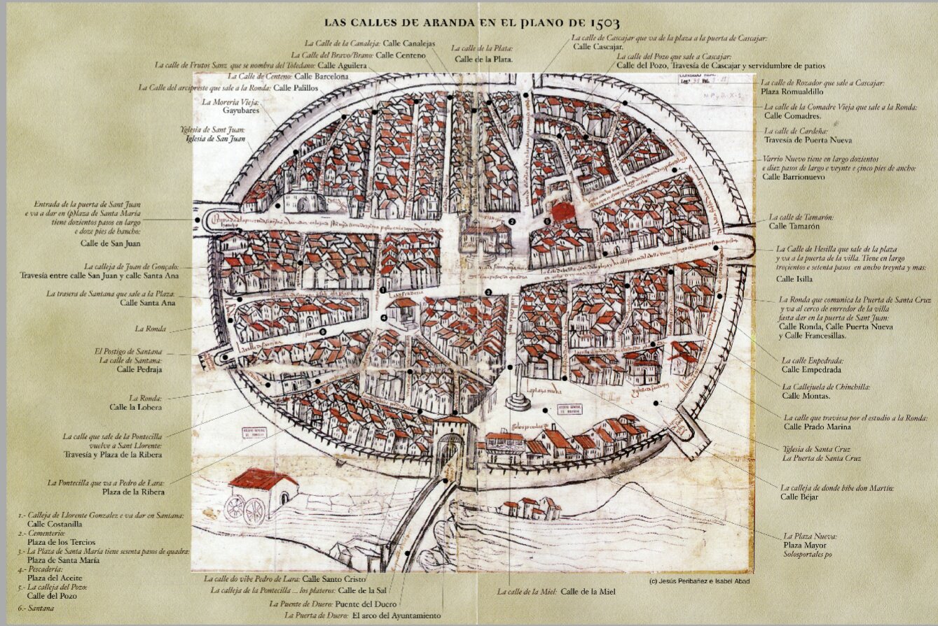
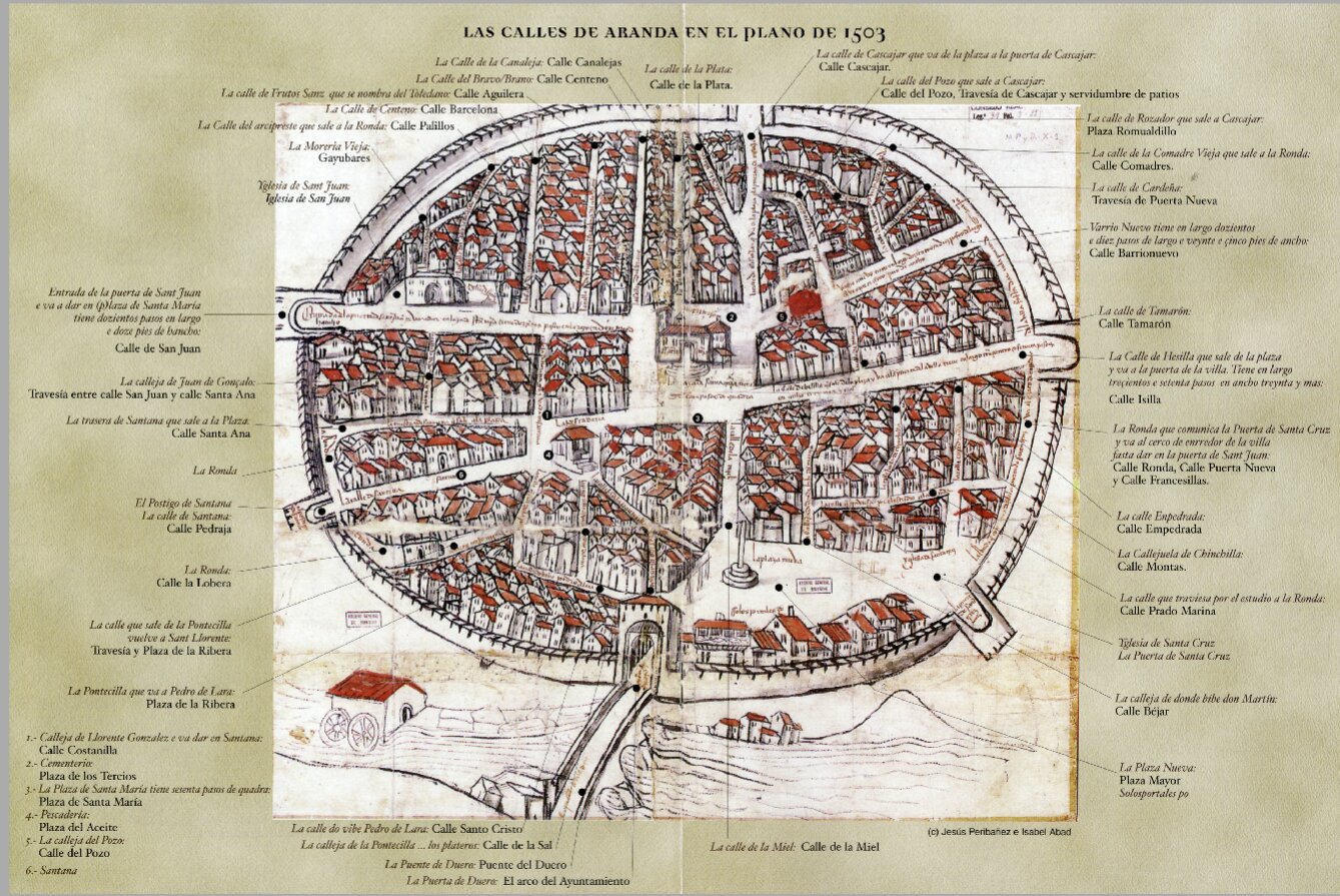
Plan of Aranda of 1503
About
- THE ORIGIN OF THE LAWSUIT:
The lawsuit originated because some of the residents of the town proposed to demolish some houses that prevented direct access to the church of Santa María from Barrionuevo street (the place in question is represented in red ink on the map). Apparently, Calle Barrionuevo and the surrounding area used to be a Jewish quarter and now “the said street has become nobler and bigger because where the said Jews used to live, now very honourable Christians live there” and “the said syn[ag]oga has become a good house”. The riots in the Calle del Pozo encouraged filth with “dead dogs and cats” and, at night, the swarming of thugs and prostitutes. Opening up Calle del Pozo would give direct access from Calle Barrio Nuevo to the Plaza de Santa María which, for the local elites, was the space of greatest political, mercantile (weekly market) and religious value, prior to the Plaza Nueva.
The owners of those houses, at the time Alonso de Moradillo and Gonzalo Sánchez de Calahorra, logically disagreed, opposing their demolition, arguing that in the basement of the buildings they owned a wine cellar with several vats where they were making wine and, if the houses were demolished to convert the site into a street, vibrations would be caused by horses and carts, causing irreparable damage. They also alleged a low price for the expropriation.
As Aranda was a royal town, both the plan and the dossier were sent to the Court of the Catholic Monarchs, who, together with the members of the Royal Council, decided on the matter: the court ruled that the houses should be demolished, subject to payment of what they were fairly worth. The houses were demolished and, since then, Calle Barrionuevo has given way to Plaza de Santa María.
These historic events made the people of Arandinos the owners of the oldest urban plan in Spain, as well as pioneers in proposing changes in the urban layout of a town.
- THE FIRST PERSPECTIVE MAP MAP IN SPAIN:
This is not the first map of a town, nor is it even the first map of a European town in perspective (the maps of Jerusalem (1487), Krakow (1493) or Venice (1500) are earlier).
The real merit of this plan lies in the fact that it is the first to be mapped in Spain in perspective, but almost from above, only a year after the great Leonardo da Vinci first drew the iconographic plan of Imola (1502).
- REPRESENTATION OF THE 1503 PLAN:
The plan also reflects the evolution of society. Aranda is presented as an enclosed town protected behind a defensive belt that adopts a circular shape, a conceptually perfect and idealised form, to differentiate it from the rurality of the surroundings. The apparent unity of the plan contrasts with the continuous urban growth through neighbourhoods outside the walls and suburbs, announced only by the small houses next to the river, avoiding the representation of the neighbourhood of Allendeduero, on the southern bank, and that of San Francisco to the east.
On the other hand, aspects of the plan herald the arrival of the Renaissance, such as the desire to give the town its own personality, to articulate the interior space clearly and to integrate the river as an element of urban enjoyment.
- WHERE IS IT TODAY?
This documentation is kept in the General Archive of Simancas (Valladolid) which, since 2017, has been part of UNESCO’s “Memory of the World”.
Details


